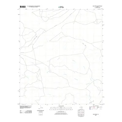
2010 Map of Oak Creek
USGS Topo · Published 2010About this map
Oak Creek and Saucito Creek define the drainage patterns of this high-altitude landscape in Presidio County. The terrain is marked by a network of seasonal watercourses and drainage channels, including the prominent Long Draw in the northwest and Shannon Draw in the southeast corner. Transportation through this open ranching country is centered on Ranch Rd 2810, which traverses the northern half of the quadrangle. The map reveals the sparsely settled nature of the region, where water sources like Julia Creek are the primary landmarks. This survey provides a clear view of the hydrological geography and minimal road infrastructure typical of the Trans-Pecos region during the early 21st century.
Find a feature on this map
6 named features on this map. Tap any name to fly to it.
Don’t see what you’re looking for? This feature index may not catch every label — zoom into the map to look around manually.
Map Details
Editions of this 2010 Oak Creek Map
This is the sole edition of this map. No revisions or reprints were ever made.
Other maps of this area
1895 · Marfa
USGS Topo · 1:125,000
1959 · Marfa
USGS Topo · 1:250,000
1965 · Marfa
USGS Topo · 1:250,000
1983 · San Esteban Lake
USGS Topo · 1:24,000
1983 · Marfa
USGS Topo · 1:24,000
1983 · Aragon
USGS Topo · 1:24,000
1983 · Cuesta Del Burro East
USGS Topo · 1:24,000
1983 · Frenchman Hills
USGS Topo · 1:24,000
1983 · San Esteban Lake SW
USGS Topo · 1:24,000
1983 · Oak Creek
USGS Topo · 1:24,000