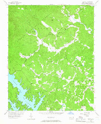
1956 Map of Oak Hill
USGS Topo · Published 1966About this map
The Linville River and Catawba River flow into the northern reaches of Lake James, forming a complex shoreline that dominates the southwestern corner of this mid-century survey. The landscape is defined by the steep transition from the Pisgah National Forest highlands down to the rolling agricultural lands of Quaker Meadow. This area shows a dense network of community life centered on numerous small rural congregations, including Quaker Meadow Ch, Smyrna Ch, and Grand View Ch, reflecting the deep-seated settlement patterns of Burke County.
Find a feature on this map
36 named features on this map. Tap any name to fly to it.
Don’t see what you’re looking for? This feature index may not catch every label — zoom into the map to look around manually.
Map Details
Editions of this 1956 Oak Hill Map
2 editions found
Other maps of this area

1905 · Morganton
USGS Topo · 1:125,000

1934 · Linville Falls
USGS Topo · 1:24,000

1953 · Charlotte
USGS Topo · 1:250,000

1954 · Charlotte
USGS Topo · 1:250,000

1956 · Oak Hill
USGS Topo · 1:24,000

1956 · Collettsville
USGS Topo · 1:24,000

1956 · Morganton North
USGS Topo · 1:24,000

1956 · Ashford
USGS Topo · 1:24,000
1956 · Linville Falls
USGS Topo · 1:24,000

1956 · Morganton South
USGS Topo · 1:24,000