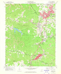
1969 Map of Oak Hill
USGS Topo · Published 1973About this map
The industrial and community landscape of Fayette County is defined here by a dense network of coal-related infrastructure and established settlements. In the northern section, Oak Hill and its surrounding neighborhoods like Rosedale and East Oak Hill show significant development, with local landmarks such as Collins High Sch and the Radio Tower (WOAY) serving as community anchors. The regional economy is evidenced by numerous Strip Mine sites, Tipple locations, and an Air Shaft near Carlisle, all interconnected by the Norfolk And Western and Chesapeake And Ohio railroads.
Find a feature on this map
109 named features on this map. Tap any name to fly to it.
Don’t see what you’re looking for? This feature index may not catch every label — zoom into the map to look around manually.
Map Details
Editions of this 1969 Oak Hill Map
3 editions found
Other maps of this area

1891 · Raleigh
USGS Topo · 1:125,000

1897 · Kanawha Falls
USGS Topo · 1:125,000

1897 · Raleigh
USGS Topo · 1:125,000

1900 · Kanawha Falls
USGS Topo · 1:125,000

1901 · Kanawha Falls
USGS Topo · 1:125,000

1902 · Raleigh
USGS Topo · 1:125,000

1908 · Fayetteville
USGS Topo · 1:48,000

1908 · Montgomery
USGS Topo · 1:48,000

1910 · Fayetteville
USGS Topo · 1:62,500

1910 · Montgomery
USGS Topo · 1:62,500