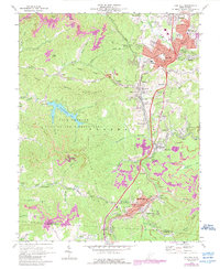
1969 Map of Oak Hill
USGS Topo · Published 1989About this map
The Plateau of West Virginia’s coal country is defined here by the industrial corridor of the Chesapeake and Ohio railroad, which links together a dense network of mining towns and company settlements. Major hubs like Oak Hill and Mount Hope show significant mid-century development, including residential expansion into East Oak Hill and Bays Heights. This 1969 survey, updated with 1980s aerial data, reveals the concentrated settlement pattern characteristic of the Fayette County coalfield, where towns like Kilsyth, Macdonald, and Glen Jean are tightly packed along the narrow valleys of Dunloup Creek.
Find a feature on this map
83 named features on this map. Tap any name to fly to it.
Don’t see what you’re looking for? This feature index may not catch every label — zoom into the map to look around manually.
Map Details
Editions of this 1969 Oak Hill Map
3 editions found
Other maps of this area

1891 · Raleigh
USGS Topo · 1:125,000

1897 · Kanawha Falls
USGS Topo · 1:125,000

1897 · Raleigh
USGS Topo · 1:125,000

1900 · Kanawha Falls
USGS Topo · 1:125,000

1901 · Kanawha Falls
USGS Topo · 1:125,000

1902 · Raleigh
USGS Topo · 1:125,000

1908 · Fayetteville
USGS Topo · 1:48,000

1908 · Montgomery
USGS Topo · 1:48,000

1910 · Fayetteville
USGS Topo · 1:62,500

1910 · Montgomery
USGS Topo · 1:62,500