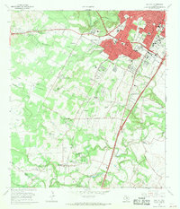
1966 Map of Oak Hill
USGS Topo · Published 1969About this map
The expanding southwestern edge of Austin meets the rural Travis County landscape in this late 1960s survey. The Missouri Pacific railroad corridor serves as a central spine, passing through the settlement of Manchaca and the A F Siding. To the west, the terrain is defined by the winding paths of Williamson Creek, Slaughter Creek, and Bear Creek, where land remains largely open except for clustered communities like Kineheonville and Ford Oaks.
Find a feature on this map
58 named features on this map. Tap any name to fly to it.
Don’t see what you’re looking for? This feature index may not catch every label — zoom into the map to look around manually.
Map Details
Editions of this 1966 Oak Hill Map
2 editions found
Other maps of this area

1896 · Austin
USGS Topo · 1:125,000

1897 · Austin
USGS Topo · 1:125,000

1910 · Austin
USGS Topo · 1:125,000

1932 · Mt. Bonnell
USGS Topo · 1:62,500

1954 · Austin East
USGS Topo · 1:24,000

1954 · Austin West
USGS Topo · 1:24,000

1954 · Austin
USGS Topo · 1:250,000

1955 · Montopolis
USGS Topo · 1:24,000

1955 · Oak Hill
USGS Topo · 1:24,000

1955 · Montopolis
USGS Topo · 1:62,500