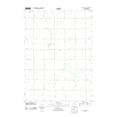
2012 Map of Oak Hollow
USGS Topo · Published 2012About this map
Oak Hollow defines this landscape in Charles Mix County, where the plains are etched by the meandering courses of Emanuel Cr and Dry Choteau Cr. The 2012 topography shows a deeply structured agricultural grid, where section lines are maintained as gravel roads like 406th Ave and 290th St. Central to the quadrangle is Tripp Lake, a significant water feature accessed by the appropriately named Tripp Lake Rd. This map captures a rural South Dakota environment where social and historical markers are sparse but significant, most notably the Oak Hollow Cem located near the center of the sheet. The persistence of these named drainage systems and the isolated cemetery provide crucial reference points for family historians tracing roots in Choteau Creek Township.
Find a feature on this map
21 named features on this map. Tap any name to fly to it.
Don’t see what you’re looking for? This feature index may not catch every label — zoom into the map to look around manually.
Map Details
Editions of this 2012 Oak Hollow Map
This is the sole edition of this map. No revisions or reprints were ever made.
Other maps of this area

1898 · Olivet
USGS Topo · 1:125,000

1955 · Sioux Falls
USGS Topo · 1:250,000

1955 · Mitchell
USGS Topo · 1:250,000

1958 · Sioux Falls
USGS Topo · 1:250,000

1959 · Mitchell
USGS Topo · 1:250,000
1972 · Dante
USGS Topo · 1:24,000

1977 · Oak Hollow
USGS Topo · 1:24,000

1978 · Oak Hollow
USGS Topo · 1:24,000
1978 · Haucks Lake
USGS Topo · 1:24,000
1978 · Avon
USGS Topo · 1:24,000
Featured Places
- Choteau Creek Township, SD
- Monroe Township, SD
- East Choteau Township, SD
- Oak Hollow Township, SD
- Bon Homme County, SD