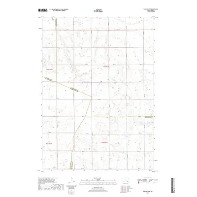
2017 Map of Oak Hollow
USGS Topo · Published 2017About this map
Oak Hollow defines this landscape where four South Dakota counties converge: Douglas, Hutchinson, Charles Mix, and Bon Homme. In this upland prairie region, the land is organized by an exacting grid of section roads including 286th St and 294th St. A key genealogical and historical landmark is the Oak Hollow Cem, situated near the center of the township. Water features are sparse but significant to the local geography, featuring the seasonal Dry Choteau Cr and the waters of Tripp Lake. The map illustrates the persistent 19th-century township-and-range surveying system as it continues to shape the modern rural agricultural layout of t97n r61w and surrounding townships.
Find a feature on this map
23 named features on this map. Tap any name to fly to it.
Don’t see what you’re looking for? This feature index may not catch every label — zoom into the map to look around manually.
Map Details
Editions of this 2017 Oak Hollow Map
This is the sole edition of this map. No revisions or reprints were ever made.
Other maps of this area

1898 · Olivet
USGS Topo · 1:125,000

1955 · Sioux Falls
USGS Topo · 1:250,000

1955 · Mitchell
USGS Topo · 1:250,000

1958 · Sioux Falls
USGS Topo · 1:250,000

1959 · Mitchell
USGS Topo · 1:250,000
1972 · Dante
USGS Topo · 1:24,000

1977 · Oak Hollow
USGS Topo · 1:24,000

1978 · Oak Hollow
USGS Topo · 1:24,000
1978 · Haucks Lake
USGS Topo · 1:24,000
1978 · Avon
USGS Topo · 1:24,000
Featured Places
- Choteau Creek Township, SD
- Monroe Township, SD
- East Choteau Township, SD
- Oak Hollow Township, SD
- Bon Homme County, SD