
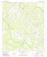
1970 Map of Oak Park
USGS Topo · Published 1973About this map
Oak Park serves as the central hub of this 1970s Emanuel County landscape, where the Georgia and Florida Railroad cuts a straight line through the pines. The geography is defined by a dense network of watercourses, including the Ohoopee River in the northeast and the wide, swampy basin of Pendleton Creek. The region is notably saturated with family and community burial grounds, such as Harrell Cem, Findley Cem, and White Chapel Cem, reflecting a deeply rooted rural population. To the west, the small settlement of Normantown sits near the crossing of Tiger Creek. The map documents a transition from established agriculture toward more industrial forest management, evidenced by the numerous unnamed secondary roads and a Jeep Trail winding through the creek bottoms near Little Reedy Creek.
Find a feature on this map
31 named features on this map. Tap any name to fly to it.
Don’t see what you’re looking for? This feature index may not catch every label — zoom into the map to look around manually.
Map Details
Editions of this 1970 Oak Park Map
2 editions found
Other maps of this area

1957 · Macon
USGS Topo · 1:250,000

1958 · Macon
USGS Topo · 1:250,000

1964 · Macon
USGS Topo · 1:250,000

1970 · Cobbtown
USGS Topo · 1:24,000

1970 · Oak Park SW
USGS Topo · 1:24,000

1970 · Covena
USGS Topo · 1:24,000

1970 · Nunez
USGS Topo · 1:24,000

1970 · Vidalia
USGS Topo · 1:24,000

1970 · Ohoopee
USGS Topo · 1:24,000

1970 · Lyons
USGS Topo · 1:24,000