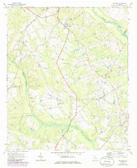
1970 Map of Oak Park
USGS Topo · Published 1986About this map
Oak Park and the surrounding pine-dappled lowlands of south-central Georgia are captured in this 1970s-era study. The landscape is defined by the slow-moving waters of the Ohoopee River and Pendleton Creek, which snake through the territory alongside the Central of Georgia Railroad. Traces of earlier transportation networks are visible in the form of an Old Railroad Grade and a Jeep Trail cutting through the woodlands.
Find a feature on this map
35 named features on this map. Tap any name to fly to it.
Don’t see what you’re looking for? This feature index may not catch every label — zoom into the map to look around manually.
Map Details
Editions of this 1970 Oak Park Map
2 editions found

Other maps of this area

1957 · Macon
USGS Topo · 1:250,000

1958 · Macon
USGS Topo · 1:250,000

1964 · Macon
USGS Topo · 1:250,000

1970 · Cobbtown
USGS Topo · 1:24,000

1970 · Oak Park SW
USGS Topo · 1:24,000

1970 · Covena
USGS Topo · 1:24,000

1970 · Nunez
USGS Topo · 1:24,000

1970 · Vidalia
USGS Topo · 1:24,000

1970 · Ohoopee
USGS Topo · 1:24,000

1970 · Lyons
USGS Topo · 1:24,000