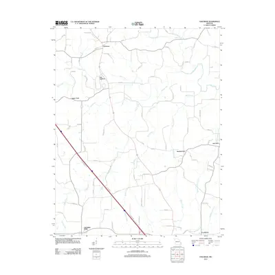
2012 Map of Oak Ridge
USGS Topo · Published 2012About this map
Old Appleton and Uniontown anchor the northern reaches of this Missouri landscape, where a dense network of local routes like Old School Rd and Little Apple Rd connects long-established farming communities. The terrain is defined by its intricate drainage patterns, with Apple Creek winding eastward through the center of the quadrangle. To the south, Shawneetown and New Wells occupy the transition toward the drainage basins of Muddy Shawnee Creek and Blue Shawnee Creek, reflecting a settlement pattern deeply tied to the local watercourses. The inclusion of Oak Ridge Ridge and the outskirts of Pocahontas further demonstrates the regional connectivity of Cape Girardeau and Perry Counties during this early 21st-century period. This survey is particularly useful for researchers tracing family lands along named tributaries such as Buckeye Creek and Hughes Creek, where the rural road system has matured around the area's natural topography.
Find a feature on this map
70 named features on this map. Tap any name to fly to it.
Don’t see what you’re looking for? This feature index may not catch every label — zoom into the map to look around manually.
Map Details
Editions of this 2012 Oak Ridge Map
This is the sole edition of this map. No revisions or reprints were ever made.
Other maps of this area

1918 · Altenburg
USGS Topo · 1:62,500

1922 · Cape Girardeau
USGS Topo · 1:62,500

1923 · Perryville
USGS Topo · 1:62,500

1924 · Cape Girardeau
USGS Topo · 1:62,500

1924 · Perryville
USGS Topo · 1:62,500

1925 · Altenburg
USGS Topo · 1:62,500

1933 · Marble Hill
USGS Topo · 1:62,500

1937 · Marble Hill
USGS Topo · 1:62,500

1947 · Crosstown
USGS Topo · 1:24,000

1947 · Oak Ridge
USGS Topo · 1:24,000