
1965 Map of Oakland
USGS Topo · Published 1967About this map
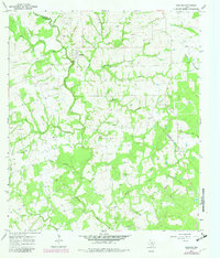
The Navidad River snakes through the borderlands of Colorado and Lavaca counties in the mid-1960s, creating a winding riparian corridor through this agricultural region. The landscape is characterized by its numerous small burial grounds and rural churches that anchor the local community history. Many of these, such as Oakland Hill Cem near the settlement of Oakland, and the Bila Hora Cem further south, reflect the generational heritage of the families farming this land. Smaller communities like Miller and Tesch are connected by a network of unimproved roads and fence lines that divide the wooded creek bottoms from the open fields. Significant watercourses including Big Rocky Creek and Clear Creek feed into the Navidad, defining the drainage patterns that have likely influenced settlement and land use for decades.
Find a feature on this map
37 named features on this map. Tap any name to fly to it.
Don’t see what you’re looking for? This feature index may not catch every label — zoom into the map to look around manually.
Map Details
Editions of this 1965 Oakland Map
2 editions found
Other maps of this area

1919 · Schulenburg
USGS Topo · 1:62,500

1953 · Seguin
USGS Topo · 1:250,000

1956 · Glidden
USGS Topo · 1:62,500

1957 · Borden
USGS Topo · 1:24,000

1958 · Seguin
USGS Topo · 1:250,000

1962 · Sublime
USGS Topo · 1:24,000

1962 · Hallettsville
USGS Topo · 1:24,000

1965 · Sawmill Branch
USGS Topo · 1:24,000
1965 · Weimar
USGS Topo · 1:24,000

1965 · Schulenburg
USGS Topo · 1:24,000