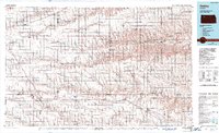
1985 Map of Oakley
USGS Topo · Published 1989About this map
Oakley serves as a significant transit hub in Western Kansas on this mid-1980s survey, where the prairie landscape is defined by the east-west corridors of the Union Pacific Railroad and Interstate 70. This regional overview illustrates the transition from the high plains to the drainage basins of the South Fork Solomon River and the Saline River. Small agricultural settlements like Grinnell, Grainfield, and Quinter line the southern rail route, while Hoxie and Rexford anchor the northern reaches of the quadrangle. Significant water resources and recreational spaces are noted, including the Sheridan State Fishing Lake and Wildlife Area and Sunny Slope Lake. The map reveals a highly organized township structure across Thomas, Sheridan, Graham, Logan, and Gove counties, reflecting the deep-rooted grid of the American West's homesteading era.
Find a feature on this map
78 named features on this map. Tap any name to fly to it.
Don’t see what you’re looking for? This feature index may not catch every label — zoom into the map to look around manually.
Map Details
Editions of this 1985 Oakley Map
2 editions found
Other maps of this area

1893 · Ellis
USGS Topo · 1:125,000

1893 · Norton
USGS Topo · 1:125,000

1893 · Hill
USGS Topo · 1:125,000

1943 · Colby
USGS Topo · 1:62,500

1951 · Selden
USGS Topo · 1:62,500

1951 · Achilles
USGS Topo · 1:62,500

1951 · Chardon
USGS Topo · 1:62,500

1954 · Goodland
USGS Topo · 1:250,000

1955 · Great Bend
USGS Topo · 1:250,000

1955 · Scott City
USGS Topo · 1:250,000