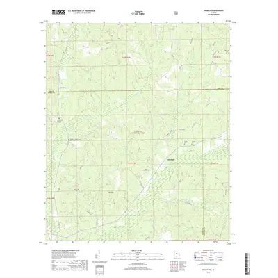
2018 Map of Oakmulgee
USGS Topo · Published 2018About this map
Talladega National Forest covers much of this landscape at the intersection of Bibb, Perry, and Chilton counties. The settlement of Oakmulgee sits along State Rte 183, serving as a central point for a region defined by its numerous family and community burial grounds. Researchers will find a high density of genealogical sites, including Bethlehem Number 1 Cem, the dual Bethlehem Number 2 Cem Harris Cem, and the Mount Olive Cem. The terrain is shaped by several drainages, such as Oakmulgee Cr and Beaverdam Cr, which flow around local high points like Bull Mtn and Hicks Hill. A network of forest and county roads, such as Holsombeck Cutoff and Mat Moore Rd, connects these remote locations, illustrating the rural settlement patterns that persist within the protected forest boundaries.
Find a feature on this map
52 named features on this map. Tap any name to fly to it.
Don’t see what you’re looking for? This feature index may not catch every label — zoom into the map to look around manually.
Map Details
Editions of this 2018 Oakmulgee Map
This is the sole edition of this map. No revisions or reprints were ever made.
Other maps of this area
1891 · Clanton
USGS Topo · 1:125,000
1953 · Montgomery
USGS Topo · 1:250,000
1956 · Montgomery
USGS Topo · 1:250,000
1957 · Montgomery
USGS Topo · 1:250,000
1959 · Plantersville
USGS Topo · 1:62,500
1959 · Summerfield
USGS Topo · 1:62,500
1971 · Maplesville West
USGS Topo · 1:24,000
1971 · Randolph
USGS Topo · 1:24,000
1979 · Harrisburg
USGS Topo · 1:24,000
1980 · Centreville East
USGS Topo · 1:24,000