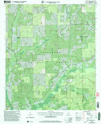
2002 Map of Oakmulgee
USGS Topo · Published 2003About this map
Talladega National Forest encompasses the vast majority of this area, preserving a landscape defined by its rolling ridges and the complex drainage systems of the Oakmulgee Creek watershed. This 2002 revision, based on surveys from the late 20th century, highlights the persistent rural character of Oakmulgee and its surrounding countryside. The map reveals a dense network of family and community landmarks, particularly churches and cemeteries like Bethlehem Ch, Mt Olive Cem, and Tabernacle Ch, which serve as vital markers for genealogical research in this part of Alabama.
Find a feature on this map
25 named features on this map. Tap any name to fly to it.
Don’t see what you’re looking for? This feature index may not catch every label — zoom into the map to look around manually.
Map Details
Editions of this 2002 Oakmulgee Map
This is the sole edition of this map. No revisions or reprints were ever made.
Other maps of this area

1891 · Clanton
USGS Topo · 1:125,000

1953 · Montgomery
USGS Topo · 1:250,000

1956 · Montgomery
USGS Topo · 1:250,000

1957 · Montgomery
USGS Topo · 1:250,000

1959 · Plantersville
USGS Topo · 1:62,500

1959 · Summerfield
USGS Topo · 1:62,500

1971 · Maplesville West
USGS Topo · 1:24,000
1971 · Randolph
USGS Topo · 1:24,000

1979 · Harrisburg
USGS Topo · 1:24,000
1980 · Centreville East
USGS Topo · 1:24,000