1983 Map of Oakridge
USGS Topo · Published 1983About this map
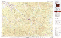
Oakridge and Westfir serve as the primary hubs in this high-altitude landscape of the western Cascades, where the Middle Fork Willamette River and its tributaries carve through deep timberlands. The economic infrastructure of the early 1980s is clearly defined by the Southern Pacific railroad line following the corridor of Oregon 58, passing through the communities of Minnow and Lowell. Major engineering projects are evident in the sprawling waters of Lookout Point Lake, Hills Creek Lake, and Dexter Res, which transformed the river valley. To the south, the rugged Calapooya Mountains reveal the region's mining history at Bohemia Mtn, featuring the Mayflower Mine and Musick Station. This map documents a transition in the Willamette National Forest, balancing industrial timber access with protected wilderness areas like the Three Sisters Wilderness and Diamond Peak Wilderness.
Find a feature on this map
168 named features on this map. Tap any name to fly to it.
Don’t see what you’re looking for? This feature index may not catch every label — zoom into the map to look around manually.
Map Details
Editions of this 1983 Oakridge Map
This is the sole edition of this map. No revisions or reprints were ever made.
Other maps of this area

1897 · Roseburg
USGS Topo · 1:125,000

1900 · Roseburg
USGS Topo · 1:125,000

1910 · Eugene
USGS Topo · 1:62,500

1917 · Diamond Lake
USGS Topo · 1:125,000

1921 · Cottage Grove
USGS Topo · 1:62,500

1925 · Waldo Lake
USGS Topo · 1:125,000

1929 · Three Sisters
USGS Topo · 1:125,000

1930 · Maiden Peak
USGS Topo · 1:125,000

1932 · Three Sisters
USGS Topo · 1:125,000

1934 · Maiden Peak
USGS Topo · 1:125,000