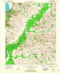
1951 Map of Oakton
USGS Topo · Published 1967About this map
The Mobile and Ohio railroad corridor anchors this survey of Hickman and Fulton counties during the early 1950s. The landscape is defined by the sharp transition from the Mississippi River floodplains to the eastern uplands, marked by the prominent Bluff and Chalk formations. Settlements like Oakton and South Columbus serve as local hubs for a rural economy tied to the rail lines and the shifting hydrology of Whayne Lake and Dry Lake.
Find a feature on this map
27 named features on this map. Tap any name to fly to it.
Don’t see what you’re looking for? This feature index may not catch every label — zoom into the map to look around manually.
Map Details
Editions of this 1951 Oakton Map
2 editions found
Other maps of this area

1939 · Wickliffe
USGS Topo · 1:62,500

1939 · Hickman
USGS Topo · 1:62,500

1951 · Cayce
USGS Topo · 1:24,000

1951 · Oakton
USGS Topo · 1:24,000

1951 · Hickman
USGS Topo · 1:24,000

1951 · Wolf Island
USGS Topo · 1:24,000

1951 · Wickliffe SW
USGS Topo · 1:24,000

1951 · Arlington
USGS Topo · 1:24,000

1951 · Milburn
USGS Topo · 1:24,000

1952 · Clinton
USGS Topo · 1:24,000