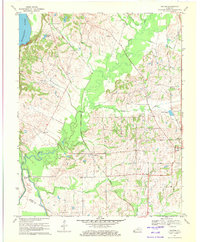
1970 Map of Oakton
USGS Topo · Published 1972About this map
The Mississippi River and its accompanying Chalk Bluff define the western edge of this 1970 landscape, where the waters of Obion Lake and Obion Creek drain toward the river's edge. The settlement of Oakton serves as a central hub in a landscape defined by its agricultural and rail infrastructure, situated along the Gulf Mobile and Ohio railroad line. To the east, the larger town of Clinton appears with its established local landmarks, including the Country Club and Sewage Disposal Ponds.
Find a feature on this map
36 named features on this map. Tap any name to fly to it.
Don’t see what you’re looking for? This feature index may not catch every label — zoom into the map to look around manually.
Map Details
Editions of this 1970 Oakton Map
2 editions found
Other maps of this area

1939 · Wickliffe
USGS Topo · 1:62,500

1939 · Hickman
USGS Topo · 1:62,500

1951 · Cayce
USGS Topo · 1:24,000

1951 · Oakton
USGS Topo · 1:24,000

1951 · Hickman
USGS Topo · 1:24,000

1951 · Wolf Island
USGS Topo · 1:24,000

1951 · Wickliffe SW
USGS Topo · 1:24,000

1951 · Arlington
USGS Topo · 1:24,000

1951 · Milburn
USGS Topo · 1:24,000

1952 · Clinton
USGS Topo · 1:24,000