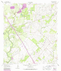
1964 Map of Oakville
USGS Topo · Published 1986About this map
Oakville serves as the central hub of this South Texas landscape, situated along the winding banks of Sulphur Creek. By the mid-1960s, the region's economy was deeply defined by energy extraction, evidenced by the extensive Karon Gas Field and Harris Oil Field. The terrain is etched with numerous drainage features, from the deep incisions of Sand Hollow and Friday Hollow to the varied gullies like Vatoss Gully and Wallet Gully.
Find a feature on this map
26 named features on this map. Tap any name to fly to it.
Don’t see what you’re looking for? This feature index may not catch every label — zoom into the map to look around manually.
Map Details
Editions of this 1964 Oakville Map
2 editions found
Other maps of this area

1920 · Mikeska
USGS Topo · 1:125,000

1925 · Oakville No. 4
USGS Topo · 1:48,000

1927 · Oakville
USGS Topo · 1:62,500

1936 · Pettus
USGS Topo · 1:62,500

1953 · Crystal City
USGS Topo · 1:250,000

1953 · Beeville
USGS Topo · 1:250,000

1954 · Fleming
USGS Topo · 1:62,500

1955 · Crystal City
USGS Topo · 1:250,000

1956 · Suniland
USGS Topo · 1:62,500

1956 · Beeville
USGS Topo · 1:250,000