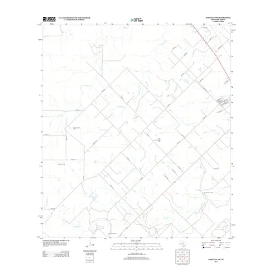
2013 Map of Oakville SW
USGS Topo · Published 2013About this map
Extensive petroleum development dominates this portion of South Texas, as evidenced by a dense concentration of named oil fields across the landscape. The extraction economy is clearly defined by the Maxine Oil Field, Maxine East Oil Field, and the West George West Oil Field. These sites are linked by a web of county roads and farm-to-market routes, including FM-889 and FM-3336, which cut through a terrain drained by seasonal waterways like Salt Br and Timon Cr. In the southeast, the Christensen Oil Field and Clay West Oil Field flank the winding path of Spring Cr. This landscape reflects the modern industrial character of Live Oak County, where the grid of rural infrastructure supports significant energy production alongside natural landmarks like Katzfey Lake and McKimzey Cr.
Find a feature on this map
50 named features on this map. Tap any name to fly to it.
Don’t see what you’re looking for? This feature index may not catch every label — zoom into the map to look around manually.
Map Details
Editions of this 2013 Oakville SW Map
This is the sole edition of this map. No revisions or reprints were ever made.
Other maps of this area

1920 · Mikeska
USGS Topo · 1:125,000

1925 · Oakville No. 4
USGS Topo · 1:48,000

1925 · Simmons No. 1
USGS Topo · 1:48,000

1927 · Oakville
USGS Topo · 1:62,500

1929 · Simmons
USGS Topo · 1:62,500

1953 · Crystal City
USGS Topo · 1:250,000

1955 · Crystal City
USGS Topo · 1:250,000

1961 · Crystal City
USGS Topo · 1:250,000
1963 · Crater Ridge
USGS Topo · 1:24,000
1963 · Elm Creek
USGS Topo · 1:24,000