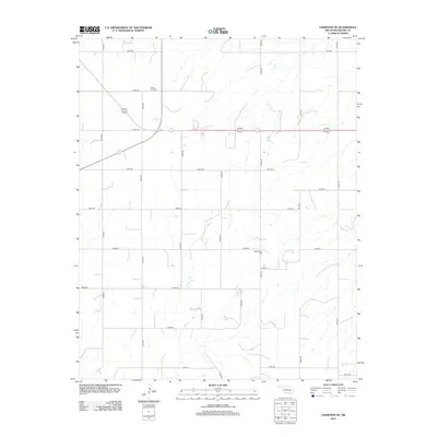
2012 Map of Oakwood SE
USGS Topo · Published 2012About this map
The rolling plains of Blaine County are defined by a meticulous grid of rural routes and the gentle drainage of several prairie streams. Agricultural life in this region is anchored by local landmarks such as Rising Sun Cem in the north and Mt Pleasant Cem further south, which serve as quiet markers of the community’s generational history. The landscape is shaped by the presence of water management features like Scott Dam, situated along the upper reaches of local drainages that eventually feed into Weavers Cr and Chicken Cr. This 2012 survey illustrates the enduring township-and-range section line system, with roads such as n2470 RD and e0840 RD providing the primary framework for the area's contemporary farm-to-market connectivity.
Find a feature on this map
25 named features on this map. Tap any name to fly to it.
Don’t see what you’re looking for? This feature index may not catch every label — zoom into the map to look around manually.
Map Details
Editions of this 2012 Oakwood SE Map
This is the sole edition of this map. No revisions or reprints were ever made.
Other maps of this area

1942 · Geary
USGS Topo · 1:62,500

1955 · Clinton
USGS Topo · 1:250,000

1957 · Clinton
USGS Topo · 1:250,000

1964 · Oakwood
USGS Topo · 1:62,500

1964 · Weatherford
USGS Topo · 1:62,500

1972 · Watonga
USGS Topo · 1:24,000
1972 · Watonga Lake
USGS Topo · 1:24,000

1979 · Greenfield
USGS Topo · 1:24,000
1985 · Eagle City
USGS Topo · 1:24,000
1985 · Watonga
USGS Topo · 1:100,000