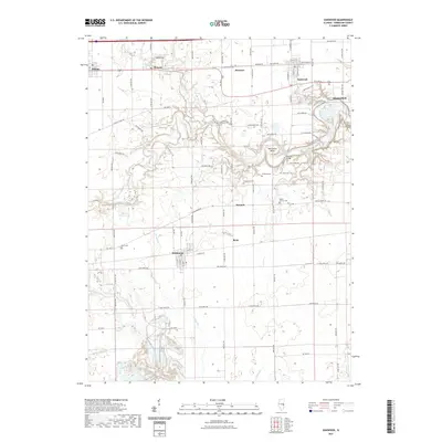
2021 Map of Oakwood
USGS Topo · Published 2021About this map
Fairmount and Oakwood anchor this survey of east-central Illinois, where the landscape is defined by the winding course of the Salt Fork river. The river carves through the terrain, creating distinctive features like Horseshoe Bend and providing a backdrop for the Singing Bridge near Camp Drake Road. This area is characterized by a dense network of township roads and scattered rural settlements such as Fithian, Muncie, and Bronson. Genealogists will find several family and community burial grounds, including Dougherty Cem, Hickman Cem, and Mount Vernon Cem. The southern portion of the map reveals the water-rich landscape around Marvin Puzey Lake and the various tributaries like Jordan Cr and Stony Creek that feed into the larger river system. The settlement of Missionfield sits on the eastern edge, highlighting the small-town clusters that developed along the rail and road corridors of Vermilion County.
Find a feature on this map
87 named features on this map. Tap any name to fly to it.
Don’t see what you’re looking for? This feature index may not catch every label — zoom into the map to look around manually.
Map Details
Editions of this 2021 Oakwood Map
This is the sole edition of this map. No revisions or reprints were ever made.
Other maps of this area

1899 · Danville
USGS Topo · 1:62,500

1900 · Danville
USGS Topo · 1:62,500

1931 · Fithian
USGS Topo · 1:48,000

1943 · Fithian
USGS Topo · 1:62,500

1947 · Ridge Farm
USGS Topo · 1:62,500

1948 · Danville NW
USGS Topo · 1:24,000

1949 · Danville SW
USGS Topo · 1:24,000

1950 · Danville SW
USGS Topo · 1:24,000

1950 · Danville NW
USGS Topo · 1:24,000

1953 · Danville
USGS Topo · 1:250,000