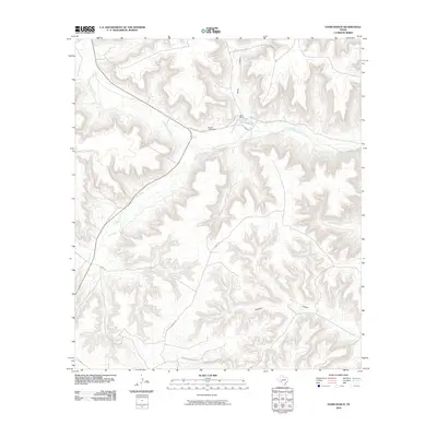
2010 Map of Oasis Ranch
USGS Topo · Published 2010About this map
Oasis Ranch serves as a lone point of habitation amidst the dissected plateau of Terrell County, where narrow canyons and seasonal drainages define the landscape. The geography is dominated by the winding course of Independence Creek, which provides a rare permanent or semi-permanent water source in this arid environment. Significant infrastructure includes the Roden Lake Dam, an essential water management feature for the ranch's operations. The surrounding terrain is marked by prominent natural features such as North Canyon and Richland Canyon, illustrating the intense erosion patterns of the Texas Trans-Pecos. Access to this isolated area relies on a sparse network of unpaved tracks, including Independence Creek Rd and Richland Springs Rd, which connect the remote ranch complex to the broader region.
Find a feature on this map
10 named features on this map. Tap any name to fly to it.
Don’t see what you’re looking for? This feature index may not catch every label — zoom into the map to look around manually.
Map Details
Editions of this 2010 Oasis Ranch Map
This is the sole edition of this map. No revisions or reprints were ever made.
Other maps of this area

1929 · Sheffield
USGS Topo · 1:125,000

1954 · Sonora
USGS Topo · 1:250,000

1958 · Sonora
USGS Topo · 1:250,000

1967 · Horsehead Canyon
USGS Topo · 1:24,000

1967 · Sheffield SE
USGS Topo · 1:24,000

1967 · Dead Man Canyon
USGS Topo · 1:24,000

1973 · Post Canyon
USGS Topo · 1:24,000
1973 · Sixshooter Canyon
USGS Topo · 1:24,000
1980 · Geddis Canyon East
USGS Topo · 1:24,000
1980 · Geddis Canyon West
USGS Topo · 1:24,000