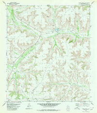
1980 Map of Oasis Ranch
USGS Topo · Published 1980About this map
Oasis Ranch stands as a primary point of interest in this West Texas landscape, situated along the winding course of Independence Creek. By the early 1980s, the terrain was defined by a mix of traditional ranching and modern industrial infrastructure, as evidenced by a network of Pipeline segments and numerous extraction sites including Gas Wells, Drill Holes, and a Well. The rugged geography is further detailed by Richland Canyon and North Canyon, which shape the local drainage patterns alongside Dry Creek. Human activity in this remote region is marked by specialized transportation and communication features, including a Landing Strip, several Jeep Trails, and a prominent Radio Tower. The presence of scattered Tanks underscores the critical importance of water management for livestock and operations in this arid Terrell County environment.
Find a feature on this map
17 named features on this map. Tap any name to fly to it.
Don’t see what you’re looking for? This feature index may not catch every label — zoom into the map to look around manually.
Map Details
Editions of this 1980 Oasis Ranch Map
This is the sole edition of this map. No revisions or reprints were ever made.
Other maps of this area

1929 · Sheffield
USGS Topo · 1:125,000

1954 · Sonora
USGS Topo · 1:250,000

1958 · Sonora
USGS Topo · 1:250,000

1967 · Horsehead Canyon
USGS Topo · 1:24,000

1967 · Sheffield SE
USGS Topo · 1:24,000

1967 · Dead Man Canyon
USGS Topo · 1:24,000

1973 · Post Canyon
USGS Topo · 1:24,000
1973 · Sixshooter Canyon
USGS Topo · 1:24,000
1980 · Geddis Canyon East
USGS Topo · 1:24,000
1980 · Geddis Canyon West
USGS Topo · 1:24,000