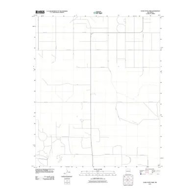
2010 Map of Oasis State Park
USGS Topo · Published 2010About this map
An agricultural grid defines this high plains landscape south of Cannon AFB in the early 21st century. The terrain is structured by a network of rural thoroughfares, most notably Oasis Rd and Baseline Rd, which serve as primary east-west arteries for the surrounding farmsteads. The quadrangle captures the transition between the section-line roads of Curry County and those of Roosevelt County, evident in the shift to labels like N Roosevelt Road 1 and S Roosevelt Rd N. This region is characterized by large-scale land management, where small water features and scattered structures are connected by an extensive system of secondary routes such as County Rd 7, Curry Road 3, and Curry Road 5. The layout reflects the enduring influence of the Public Land Survey System on the development and modern navigation of the eastern New Mexico plains.
Find a feature on this map
20 named features on this map. Tap any name to fly to it.
Don’t see what you’re looking for? This feature index may not catch every label — zoom into the map to look around manually.
Map Details
Editions of this 2010 Oasis State Park Map
This is the sole edition of this map. No revisions or reprints were ever made.
Other maps of this area

1954 · Clovis
USGS Topo · 1:250,000

1957 · Portair
USGS Topo · 1:62,500

1957 · Clovis
USGS Topo · 1:62,500

1957 · Arch
USGS Topo · 1:62,500

1957 · Portales
USGS Topo · 1:62,500

1958 · Clovis
USGS Topo · 1:250,000

1985 · Portair
USGS Topo · 1:24,000

1985 · Midway
USGS Topo · 1:24,000
1985 · Portales
USGS Topo · 1:24,000
1985 · Bethel
USGS Topo · 1:24,000