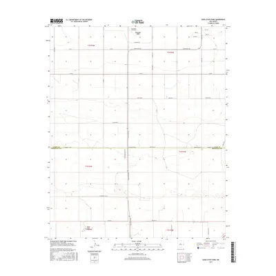
2017 Map of Oasis State Park
USGS Topo · Published 2017About this map
Cannon Air Force Base dominates the northern landscape of this High Plains quadrangle, where the grid of the High Plains meets the military infrastructure of eastern New Mexico. The boundary between Curry County and Roosevelt County bisects the map, illustrating the administrative divisions of this ranching and aviation corridor. To the south, Oasis State Park provides a concentrated area of managed terrain near Oasis Road, standing in contrast to the surrounding agricultural sections. The map traces the transition from base housing and named streets like Jesse Ave and Ora Dr into the expansive rural network of New Mexico 467 and Wildflower Ranch Road, documenting the road system and section lines that define the area's development.
Find a feature on this map
29 named features on this map. Tap any name to fly to it.
Don’t see what you’re looking for? This feature index may not catch every label — zoom into the map to look around manually.
Map Details
Editions of this 2017 Oasis State Park Map
This is the sole edition of this map. No revisions or reprints were ever made.
Other maps of this area

1954 · Clovis
USGS Topo · 1:250,000

1957 · Portair
USGS Topo · 1:62,500

1957 · Clovis
USGS Topo · 1:62,500

1957 · Arch
USGS Topo · 1:62,500

1957 · Portales
USGS Topo · 1:62,500

1958 · Clovis
USGS Topo · 1:250,000

1985 · Portair
USGS Topo · 1:24,000

1985 · Midway
USGS Topo · 1:24,000
1985 · Portales
USGS Topo · 1:24,000
1985 · Bethel
USGS Topo · 1:24,000