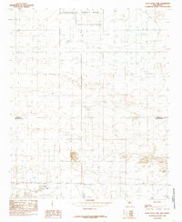
1985 Map of Oasis State Park
USGS Topo · Published 1985About this map
Oasis State Park anchors the southern portion of this high plains landscape on the border of eastern New Mexico. The area is defined by a sparse, utilitarian distribution of water resources, with numerous Well sites scattered across the township grid, reflecting the intensive groundwater reliance of the Llano Estacado. To the north, the massive footprint of the Cannon Air Force Base occupies several sections, introducing a significant federal and military presence to this otherwise agricultural and recreational district. The map captures a moment in the mid-1980s when the boundary between Curry Co and Roosevelt Co divided a landscape of cattle ranching, isolated farmsteads, and the developing infrastructure of a Pipeline network. The terrain is relatively flat, characterized by subtle depressions and the intentional preservation of the park's sand dune and woodland environment.
Find a feature on this map
5 named features on this map. Tap any name to fly to it.
Don’t see what you’re looking for? This feature index may not catch every label — zoom into the map to look around manually.
Map Details
Editions of this 1985 Oasis State Park Map
This is the sole edition of this map. No revisions or reprints were ever made.
Other maps of this area

1954 · Clovis
USGS Topo · 1:250,000

1957 · Portair
USGS Topo · 1:62,500

1957 · Clovis
USGS Topo · 1:62,500

1957 · Arch
USGS Topo · 1:62,500

1957 · Portales
USGS Topo · 1:62,500

1958 · Clovis
USGS Topo · 1:250,000

1985 · Portair
USGS Topo · 1:24,000

1985 · Midway
USGS Topo · 1:24,000
1985 · Portales
USGS Topo · 1:24,000
1985 · Bethel
USGS Topo · 1:24,000