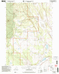
2004 Map of Oatman Flat
USGS Topo · Published 2007About this map
Fremont National Forest defines this high desert landscape, where the volcanic topography of Oat Butte and Wing Butte transitions into the wide, arid expanse of Oatman Flat. The map documents a sparsely populated region of Oregon's interior, marked by isolated homesteads and seasonal camps such as Stratton Place, Deadmond Place, and Freeman Dry Camp. These named locations, often situated near vital water sources like Baskin Spring or Lily Lake, reflect the area's history of ranching and natural resource management.
Find a feature on this map
25 named features on this map. Tap any name to fly to it.
Don’t see what you’re looking for? This feature index may not catch every label — zoom into the map to look around manually.
Map Details
Editions of this 2004 Oatman Flat Map
This is the sole edition of this map. No revisions or reprints were ever made.
Other maps of this area

1955 · Crescent
USGS Topo · 1:250,000

1957 · Crescent
USGS Topo · 1:250,000

1958 · Crescent
USGS Topo · 1:250,000

1968 · Silver Lake
USGS Topo · 1:24,000

1968 · Rodman Rock
USGS Topo · 1:24,000

1968 · Oatman Flat
USGS Topo · 1:24,000
1968 · Hager Mtn
USGS Topo · 1:24,000
1968 · Antelope Mtn
USGS Topo · 1:24,000
1968 · Bridge Creek Draw
USGS Topo · 1:24,000

1970 · Crescent
USGS Topo · 1:250,000