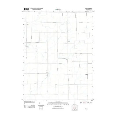
2012 Map of Obed
USGS Topo · Published 2012About this map
Agricultural homesteads and small prairie settlements define this area of Shelby County during the early 21st century. The central crossroads of Pleak and the nearby community of Obed serve as the primary landmarks in an landscape otherwise dominated by a rigid grid of rural routes like 1100 E Shelby Co and 2600 N Shelby Co. The distribution of burial grounds throughout the countryside—including Masonic Cem, Little Flock Cem, and Salem Cem—offers significant points of interest for genealogists tracing long-established families in the region. Waterways such as Flat Br and Wilborn Cr break the geometric road pattern, indicating the natural drainage routes that shaped the early siting of these rural Illinois outposts. Toward the southeast, the small cluster at Yantisville further illustrates the scattered, community-focused development of this farming district.
Find a feature on this map
53 named features on this map. Tap any name to fly to it.
Don’t see what you’re looking for? This feature index may not catch every label — zoom into the map to look around manually.
Map Details
Editions of this 2012 Obed Map
This is the sole edition of this map. No revisions or reprints were ever made.
Other maps of this area

1942 · Shelbyville
USGS Topo · 1:62,500

1946 · Shelbyville
USGS Topo · 1:62,500

1947 · Pana
USGS Topo · 1:62,500

1949 · Dalton City
USGS Topo · 1:62,500

1949 · Pana
USGS Topo · 1:62,500

1952 · Assumption
USGS Topo · 1:62,500

1958 · Decatur
USGS Topo · 1:250,000

1961 · Decatur
USGS Topo · 1:250,000
1981 · Shelbyville
USGS Topo · 1:24,000
1981 · Tower Hill
USGS Topo · 1:24,000