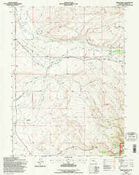
1992 Map of Oberg Ranch
USGS Topo · Published 1996About this map
Overland Flats and the neighboring Lake Flats define this high-altitude Carbon County landscape, where complex irrigation systems support isolated ranching operations. The map details an extensive network of water management, including the Nickel Scribner Ditch, Allen Ditch, and Swan Ditch, which redirect flow across the plains to support the Oberg Ranch and Moore Ranch. Evidence of earlier settlement is found at the Old Pennock Place (Aband), while the Standard Pass Creek Sch indicates the historical community center for these remote homesteads. The southeastern corner of the quadrangle transitions into the Medicine Bow National Forest, marking the shift from open grazing land to protected timber. Transport in the region is dominated by the Overland Road and several four-wheel-drive tracks that follow the natural contours of Pass Creek and its various forks.
Find a feature on this map
31 named features on this map. Tap any name to fly to it.
Don’t see what you’re looking for? This feature index may not catch every label — zoom into the map to look around manually.
Map Details
Editions of this 1992 Oberg Ranch Map
This is the sole edition of this map. No revisions or reprints were ever made.
Other maps of this area

1893 · Fort Steele
USGS Topo · 1:125,000

1939 · Saratoga
USGS Topo · 1:125,000

1954 · Rawlins
USGS Topo · 1:250,000

1955 · Overland
USGS Topo · 1:24,000

1955 · Coal Bank Basin
USGS Topo · 1:24,000

1955 · Oberg Ranch
USGS Topo · 1:24,000

1955 · Meads
USGS Topo · 1:24,000

1955 · Rattlesnake Pass
USGS Topo · 1:24,000

1955 · Coad Mountain
USGS Topo · 1:24,000

1958 · Rawlins
USGS Topo · 1:250,000