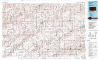
1985 Map of Oberlin
USGS Topo · Published 1989About this map
Beaver Creek and Sappa Creek carve through the high plains of Northwest Kansas, defining the drainage patterns of Decatur and Rawlins counties. This mid-1980s landscape is dominated by the town of Oberlin, which sits at the confluence of local highways and the Burlington Northern railroad line. The map captures the agricultural grid of the era, where townships like Bassettville, Achilles, and Custer organize the prairie into a network of small settlements and family farms. To the east, the Norton State Wildlife Area provides a break from the cultivated fields. Transit and utility infrastructure are well-established, with the Municipal Airport serving as a local hub. The presence of smaller communities like Ludell, Norcatur, and Selden along the rail and river corridors illustrates the persistence of these rural service centers long after the initial settlement boom.
Find a feature on this map
70 named features on this map. Tap any name to fly to it.
Don’t see what you’re looking for? This feature index may not catch every label — zoom into the map to look around manually.
Map Details
Editions of this 1985 Oberlin Map
2 editions found
Other maps of this area

1893 · Norton
USGS Topo · 1:125,000

1893 · Hill
USGS Topo · 1:125,000

1896 · Arapahoe
USGS Topo · 1:125,000

1898 · Arapahoe
USGS Topo · 1:125,000

1943 · Colby
USGS Topo · 1:62,500

1951 · Selden
USGS Topo · 1:62,500

1951 · Norton
USGS Topo · 1:62,500

1951 · Herndon
USGS Topo · 1:62,500

1951 · Achilles
USGS Topo · 1:62,500

1951 · Atwood
USGS Topo · 1:62,500