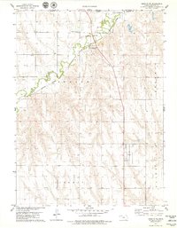
1978 Map of Oberlin NE
USGS Topo · Published 1979About this map
Cedar Bluffs serves as the primary settlement hub along the Burlington Northern line in this northern Decatur County landscape. The geography is defined by the winding course of Beaver Creek, which cuts through the townships of Beaver and Sherman. This late-1970s survey illustrates a region where rural infrastructure supports agriculture and transport, evidenced by the presence of a Feedlot and a Gaging Station situated near the railroad crossing. Genealogists and local historians can locate the Cedar Bluffs Cem perched on the bluffs north of the creek, while the mapping of numerous Wells across Liberty and Olive townships reveals the importance of water management in the High Plains. The northern margin also clearly delineates the state boundary between Nebraska and Kansas.
Find a feature on this map
16 named features on this map. Tap any name to fly to it.
Don’t see what you’re looking for? This feature index may not catch every label — zoom into the map to look around manually.
Map Details
Editions of this 1978 Oberlin NE Map
This is the sole edition of this map. No revisions or reprints were ever made.
Other maps of this area

1951 · Oberlin
USGS Topo · 1:62,500

1951 · Kanona
USGS Topo · 1:62,500

1954 · McCook
USGS Topo · 1:250,000

1954 · Goodland
USGS Topo · 1:250,000

1956 · Goodland
USGS Topo · 1:250,000

1957 · McCook
USGS Topo · 1:250,000

1957 · Goodland
USGS Topo · 1:250,000

1957 · McCook SW
USGS Topo · 1:24,000

1957 · Danbury
USGS Topo · 1:24,000

1957 · McCook SE
USGS Topo · 1:24,000