
1950 Map of Oberon SW
USGS Topo · Published 1950About this map
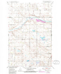
The Sheyenne River cuts a prominent path across this mid-century landscape on the border of Benson and Eddy counties. This 1950 survey, developed as part of the Missouri River Basin program, captures the rural organization of North Dakota's townships, including Oberon, Grandfield, Gates, and Munster. The influence of the Old Indian Reservation Boundary is still clearly marked across the terrain, intersecting the Northern Pacific railroad line near the river valley. Local community life is anchored by dispersed rural institutions such as the Grandfield Ch, the nearby Town Hall, and several one-room schoolhouses like School No 1 and School No 3. To the southeast, the small settlement of Divide and the Divide Sch sit near Shroyer Lake, illustrating the sparse but deliberate settlement pattern of the northern plains before the expansion of modern highway networks.
Find a feature on this map
20 named features on this map. Tap any name to fly to it.
Don’t see what you’re looking for? This feature index may not catch every label — zoom into the map to look around manually.
Map Details
Editions of this 1950 Oberon SW Map
2 editions found
Other maps of this area

1931 · Oberon
USGS Topo · 1:62,500

1932 · Flora
USGS Topo · 1:62,500

1948 · New Rockford
USGS Topo · 1:62,500

1948 · Cathay
USGS Topo · 1:62,500

1949 · Munster
USGS Topo · 1:24,000

1950 · New Rockford
USGS Topo · 1:24,000

1950 · New Rockford NE
USGS Topo · 1:24,000

1950 · Sheyenne
USGS Topo · 1:24,000

1950 · Oberon
USGS Topo · 1:62,500

1951 · Crow Hill
USGS Topo · 1:24,000