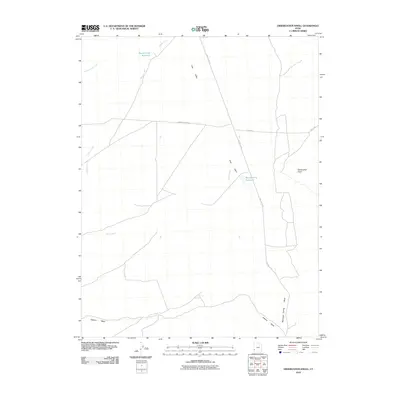
2010 Map of Observation Knoll
USGS Topo · Published 2010About this map
Pine Valley dominates this high-desert landscape in southwestern Utah, where water management defines the few footprints of human development. Sparse infrastructure is concentrated around reliable water sources like Sheep Creek Reservoir in the north and the Mackelprang Reservoir further south, both essential for livestock or irrigation in this arid environment. The terrain is marked by the eponymous Observation Knoll to the east and a network of seasonal drainages, including Pinto Creek and Cottonwood Creek, which feed into the valley floor. A handful of unpaved thoroughfares such as Hamblin Valley Rd and Pine Valley Rd connect the area, tracing the low-lying reaches of Jackson Wash and Mountain Spring Wash. This survey provides a clear view of the ranching and resource-based geography that persisted into the early 21st century.
Find a feature on this map
12 named features on this map. Tap any name to fly to it.
Don’t see what you’re looking for? This feature index may not catch every label — zoom into the map to look around manually.
Map Details
Editions of this 2010 Observation Knoll Map
This is the sole edition of this map. No revisions or reprints were ever made.
Other maps of this area

1953 · Richfield
USGS Topo · 1:250,000

1958 · Richfield
USGS Topo · 1:250,000

1971 · Observation Knoll
USGS Topo · 1:24,000

1971 · Pine Grove Reservoir
USGS Topo · 1:24,000

1971 · Pinto Spring
USGS Topo · 1:24,000

1971 · Bible Spring
USGS Topo · 1:24,000
1971 · The Tetons
USGS Topo · 1:24,000

1971 · Lamerdorf Peak
USGS Topo · 1:24,000

1971 · Steamboat Mtn
USGS Topo · 1:24,000
1972 · Mountain Spring Peak
USGS Topo · 1:24,000