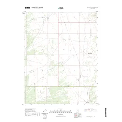
2023 Map of Observation Knoll
USGS Topo · Published 2023About this map
Observation Knoll stands as a prominent landmark at the eastern edge of Pine Valley, where the high desert terrain transitions toward the Wah Wah Mountains. This landscape is defined by its drainage systems and water management, featuring both natural drainages like Mountain Spring Wash and Jackson Wash, and man-made catchments such as Mackleprang Reservoir and Sheep Cr Reservoir. To the southwest, the Indian Peak Range marks a rugged contrast to the valley floor. The boundary between Beaver Co and Iron Co bisects the southern portion of the quadrangle, highlighting the area's jurisdictional division. Limited access is provided by unpaved routes including Pine Valley Rd and Jockey Rd, reflecting the remote ranching or grazing character of the region. This 2023 survey documents the modern state of these seasonal water sources and the established network of washes, such as Pinto Creek and Pine Valley Wash, that shape the alluvial fans of southwest Utah.
Find a feature on this map
15 named features on this map. Tap any name to fly to it.
Don’t see what you’re looking for? This feature index may not catch every label — zoom into the map to look around manually.
Map Details
Editions of this 2023 Observation Knoll Map
This is the sole edition of this map. No revisions or reprints were ever made.
Other maps of this area

1953 · Richfield
USGS Topo · 1:250,000

1958 · Richfield
USGS Topo · 1:250,000

1971 · Observation Knoll
USGS Topo · 1:24,000

1971 · Pine Grove Reservoir
USGS Topo · 1:24,000

1971 · Pinto Spring
USGS Topo · 1:24,000

1971 · Bible Spring
USGS Topo · 1:24,000
1971 · The Tetons
USGS Topo · 1:24,000

1971 · Lamerdorf Peak
USGS Topo · 1:24,000

1971 · Steamboat Mtn
USGS Topo · 1:24,000
1972 · Mountain Spring Peak
USGS Topo · 1:24,000