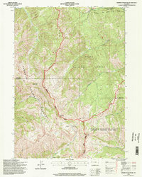
1996 Map of Observation Peak
USGS Topo · Published 1998About this map
Observation Peak and Indian Peak anchor this high-altitude section of the Snake River Range during the late 1990s. The landscape is defined by its administrative complexity, where the Targhee National Forest and Teton National Forest meet at the border of Teton and Lincoln Counties. This map documents the Palisades Wilderness Study Area, a region of protected backcountry characterized by steep drainage systems like Big Elk Creek and Coburn Creek. For researchers of western land management, the sheet illustrates the exact boundaries of the Jackson District and Palisades Ranger District, showing how these federal lands were partitioned and administered. High-mountain crossings such as North Indian Creek Pass and Red Pass provide the only established routes through the complex topography of Lake Basin and Deadhorse Canyon.
Find a feature on this map
27 named features on this map. Tap any name to fly to it.
Don’t see what you’re looking for? This feature index may not catch every label — zoom into the map to look around manually.
Map Details
Editions of this 1996 Observation Peak Map
2 editions found
Other maps of this area

1931 · Jackson
USGS Topo · 1:125,000

1932 · Irwin
USGS Topo · 1:96,000

1935 · Irwin
USGS Topo · 1:125,000

1935 · Jackson
USGS Topo · 1:125,000

1955 · Driggs
USGS Topo · 1:250,000

1958 · Driggs
USGS Topo · 1:250,000

1962 · Driggs
USGS Topo · 1:250,000

1963 · Munger Mountain
USGS Topo · 1:24,000

1963 · Jackson
USGS Topo · 1:24,000

1963 · Teton Pass
USGS Topo · 1:24,000