1963 Map of Obsidian
USGS Topo · Published 1965About this map
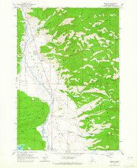
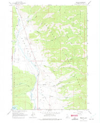
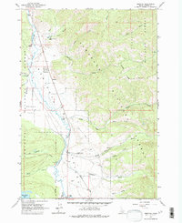
Sawtooth Valley serves as the central corridor of this 1963 survey, where the Salmon River winds through high mountain terrain between the Sawtooth National Forest and Challis National Forest. The settlement of Obsidian and the nearby Idaho Rocky Mtn Ranch mark the human footprint in an area otherwise defined by timber and drainage networks like Fourth of July Creek and Fisher Creek. The map documents early 1960s forest infrastructure, including the Sawtooth Valley Ranger Station and Bull Moose Campground. To the south, Yellow Belly Lake sits at the edge of the glacial landscape, while the presence of a Gravel Pit and several Jeep Trails indicates the active land use and resource management of the era. The wide expanse of Decker Flat contrasts with the surrounding peaks, illustrating the distinct topography of Custer County.
Find a feature on this map
32 named features on this map. Tap any name to fly to it.
Don’t see what you’re looking for? This feature index may not catch every label — zoom into the map to look around manually.
Map Details
Editions of this 1963 Obsidian Map
3 editions found
Other maps of this area

1900 · Sawtooth
USGS Topo · 1:125,000

1919 · Custer
USGS Topo · 1:125,000

1922 · Custer
USGS Topo · 1:125,000

1955 · Hailey
USGS Topo · 1:250,000

1957 · Challis
USGS Topo · 1:250,000

1959 · Hailey
USGS Topo · 1:250,000

1960 · Challis
USGS Topo · 1:250,000

1962 · Hailey
USGS Topo · 1:250,000

1963 · Challis
USGS Topo · 1:250,000
1963 · Mt Cramer
USGS Topo · 1:24,000