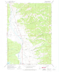
1963 Map of Obsidian
USGS Topo · Published 1975About this map
The Salmon River flows through the high elevations of the Sawtooth Valley in this early 1960s survey of Custer County. The small settlement at Obsidian and the nearby Idaho Rocky Mtn Ranch represent the sparse human footprint in a landscape dominated by the boundary between the Challis National Forest and the Sawtooth National Forest. This era predates the formal designation of the surrounding wilderness areas, showing a network of primitive access points including a Jeep Trail following Fourth of July Creek. Water features like Yellow Belly Lake and Fisher Creek are clearly delineated, along with landmarks such as the Sawtooth Valley Ranger Station. The presence of a small Prospect and several Gravel Pits indicates the minor localized resource extraction occurring alongside the emerging recreational and ranching economy of the valley.
Find a feature on this map
29 named features on this map. Tap any name to fly to it.
Don’t see what you’re looking for? This feature index may not catch every label — zoom into the map to look around manually.
Map Details
Editions of this 1963 Obsidian Map
3 editions found
Other maps of this area

1900 · Sawtooth
USGS Topo · 1:125,000

1919 · Custer
USGS Topo · 1:125,000

1922 · Custer
USGS Topo · 1:125,000

1955 · Hailey
USGS Topo · 1:250,000

1957 · Challis
USGS Topo · 1:250,000

1959 · Hailey
USGS Topo · 1:250,000

1960 · Challis
USGS Topo · 1:250,000

1962 · Hailey
USGS Topo · 1:250,000

1963 · Challis
USGS Topo · 1:250,000

1963 · Mt Cramer
USGS Topo · 1:24,000