1898 Map of Oceana
USGS Topo · Published 1902About this map
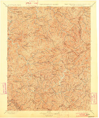
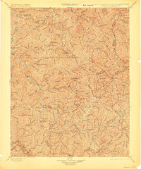
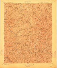
Oceana serves as a central point in this late nineteenth-century study of the southern West Virginia coalfields, situated at a time when the region's complex topography was primarily defined by its dense drainage networks and high ridges. The landscape is dominated by the massive presence of Cherry Pond Mountain and Guyandot Mountain, which dictated the early settlement patterns along the narrow valley floors. Transportation was just beginning to modernize, as evidenced by the Norfolk and Western RR cutting through the southwestern corner near Wharncliffe. Small communities like Baileysville, North Spring, and Gilbert appear connected by the many forks and branches of the river systems, including the numerous drainages of Big Creek and Marsh Fork. This survey, directed by Charles D. Walcott, captures the area before the intensive industrial expansion of the twentieth century, focusing on the fundamental geography of the county lines and high knobs like Backbone Knob and Panther Knob.
Find a feature on this map
152 named features on this map. Tap any name to fly to it.
Don’t see what you’re looking for? This feature index may not catch every label — zoom into the map to look around manually.
Map Details
Editions of this 1898 Oceana Map
4 editions found

Other maps of this area

1886 · Grundy
USGS Topo · 1:125,000

1887 · Warfield
USGS Topo · 1:125,000

1887 · Pocahontas
USGS Topo · 1:125,000

1890 · Grundy
USGS Topo · 1:125,000

1891 · Tazewell
USGS Topo · 1:125,000

1891 · Pocahontas
USGS Topo · 1:125,000

1891 · Oceana
USGS Topo · 1:125,000

1891 · Raleigh
USGS Topo · 1:125,000

1891 · Warfield
USGS Topo · 1:125,000

1892 · Grundy
USGS Topo · 1:125,000