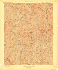
1898 Map of Oceana
USGS Topo · Published 1907About this map
Guyandot River serves as the central artery for this 1890s survey of southern West Virginia, a landscape of deep hollows and sharp ridges defined by the massive Cherry Pond Mountain and Huff Mountain. The settlement pattern at this time follows the river and its numerous tributaries, with established communities like Oceana and Pineville acting as local hubs. In the southwestern corner, the N. & W. R. R. follows the Tug Fork along the Kentucky and Virginia border, marking the early industrial entry into these coal-rich counties.
Find a feature on this map
179 named features on this map. Tap any name to fly to it.
Don’t see what you’re looking for? This feature index may not catch every label — zoom into the map to look around manually.
Map Details
Editions of this 1898 Oceana Map
4 editions found

Other maps of this area

1886 · Grundy
USGS Topo · 1:125,000

1887 · Warfield
USGS Topo · 1:125,000

1887 · Pocahontas
USGS Topo · 1:125,000

1890 · Grundy
USGS Topo · 1:125,000

1891 · Tazewell
USGS Topo · 1:125,000

1891 · Pocahontas
USGS Topo · 1:125,000

1891 · Oceana
USGS Topo · 1:125,000

1891 · Raleigh
USGS Topo · 1:125,000

1891 · Warfield
USGS Topo · 1:125,000

1892 · Grundy
USGS Topo · 1:125,000