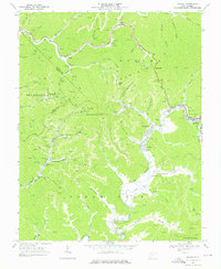
1968 Map of Oceana
USGS Topo · Published 1976About this map
Ocean Mountain towers over a landscape defined by deep-cut stream valleys and the intensive resource extraction of the late 1960s. The northern reaches follow Huff Creek through the settlements of Cyclone and Lacoma, while the southern portion centers on the winding course of the Clear Fork river. This era represents a peak of industrial activity, with Strip Mine operations, Tipple Conveyor systems, and Mine Dump sites appearing throughout the hollows. The Norfolk and Western railroad serves as the primary artery for these operations, connecting mining nodes like Coal Mountain to the larger valley. Local life is anchored by community landmarks such as Coal Mountain Sch, Cyclone Ch, and the Clear Fork Valley Ch, providing a detailed look at West Virginia coal country before later economic shifts changed the regional footprint.
Find a feature on this map
68 named features on this map. Tap any name to fly to it.
Don’t see what you’re looking for? This feature index may not catch every label — zoom into the map to look around manually.
Map Details
Editions of this 1968 Oceana Map
4 editions found
Other maps of this area

1891 · Oceana
USGS Topo · 1:125,000

1893 · Oceana
USGS Topo · 1:125,000

1898 · Oceana
USGS Topo · 1:125,000

1909 · Gilbert
USGS Topo · 1:48,000

1910 · Pineville
USGS Topo · 1:48,000

1910 · Bald Knob
USGS Topo · 1:48,000

1912 · Bald Knob
USGS Topo · 1:62,500

1912 · Gilbert
USGS Topo · 1:62,500

1912 · Pineville
USGS Topo · 1:62,500

1913 · Logan
USGS Topo · 1:62,500