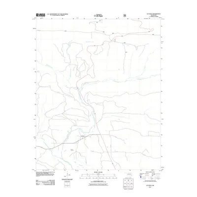
2011 Map of Octavia
USGS Topo · Published 2011About this map
Octavia serves as the central community of this section of southeastern Oklahoma, situated near the confluence of several vital waterways. The landscape is defined by the winding paths of Big Eagle Creek and Cucumber Creek, which converge just south of the settlement. For genealogists and local researchers, the Octavia Cemetery is a prominent landmark situated west of the main residential area, offering a focal point for family history in the region. The map illustrates a network of county roads, including Co RD 307 and Co RD 301, which thread through the valley floors between ridges. The drainage patterns of Saddle Rock Creek and Little Eagle Creek suggest a terrain where settlement has historically followed the natural corridors provided by these stream beds.
Find a feature on this map
17 named features on this map. Tap any name to fly to it.
Don’t see what you’re looking for? This feature index may not catch every label — zoom into the map to look around manually.
Map Details
Editions of this 2011 Octavia Map
This is the sole edition of this map. No revisions or reprints were ever made.
Other maps of this area

1900 · Winding Stair
USGS Topo · 1:125,000

1902 · Lukfata
USGS Topo · 1:125,000

1909 · Winding Stair
USGS Topo · 1:125,000

1950 · Mcalester
USGS Topo · 1:250,000

1959 · Page
USGS Topo · 1:62,500

1960 · Bethel
USGS Topo · 1:62,500

1960 · Smithville
USGS Topo · 1:62,500

1962 · McAlester
USGS Topo · 1:250,000

1965 · McAlester
USGS Topo · 1:250,000
1966 · Muse
USGS Topo · 1:24,000