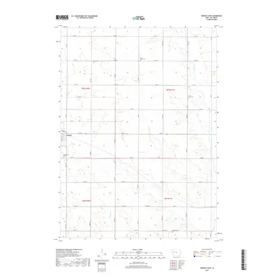
2018 Map of Odebolt East
USGS Topo · Published 2018About this map
The settlement of Odebolt anchors the western edge of this agricultural landscape in Sac County, where the town street grid transitions into a vast network of section roads. For genealogists, the map is remarkably dense with rural burial sites, including Richland Cem, Salem Reform Cem, Clinton Center Cem, and Tom Marks Cem scattered across the townships. These locations, often situated near the heads of small drainage systems like Wheeler Cr, reflect the early settlement patterns of the region's farming families. The natural drainage of the land is defined by the Boyer River in the east and Odebolt Cr in the west, carving subtle relief into the prairie. The rigid alignment of roads such as Fox Ave and 330th St illustrates the enduring influence of the Public Land Survey System on the modern Iowa landscape.
Find a feature on this map
38 named features on this map. Tap any name to fly to it.
Don’t see what you’re looking for? This feature index may not catch every label — zoom into the map to look around manually.
Map Details
Editions of this 2018 Odebolt East Map
This is the sole edition of this map. No revisions or reprints were ever made.
Other maps of this area

1954 · Fort Dodge
USGS Topo · 1:250,000

1957 · Fort Dodge
USGS Topo · 1:250,000

1958 · Fort Dodge
USGS Topo · 1:250,000

1971 · Kiron
USGS Topo · 1:24,000

1980 · Odebolt East
USGS Topo · 1:24,000

1980 · Early
USGS Topo · 1:24,000

1980 · Lake View
USGS Topo · 1:24,000
1980 · Sac City West
USGS Topo · 1:24,000

1980 · Boyer
USGS Topo · 1:24,000
1980 · Vail NE
USGS Topo · 1:24,000