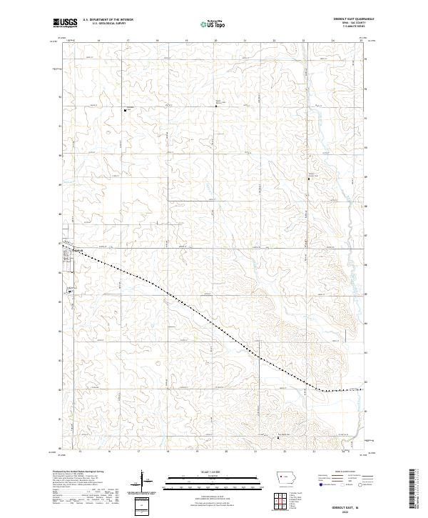
2022 Map of Odebolt East
USGS Topo · Published 2022About this map
The town of Odebolt sits at the western edge of this agricultural landscape in Sac County, Iowa, serving as the primary hub for the surrounding farmsteads. The terrain is defined by the gentle drainage of the Boyer River and its various tributaries, including Fiddlers Cr and Odebolt Cr. This survey reveals a deeply rooted rural community, evidenced by several family and township burial grounds scattered across the grid-iron road network, such as Richland Cem and the Tom Marks Cem. The presence of Salem Reform Cem and Clinton Center Cem suggests early settlement patterns and the historical centers of small, localized neighborhoods that formed along county lines. The rectangular survey system remains the dominant influence on the modern map, with roads like 330th St and Jackson Ave following the original township and section boundaries.
Find a feature on this map
39 named features on this map. Tap any name to fly to it.
Don’t see what you’re looking for? This feature index may not catch every label — zoom into the map to look around manually.
Map Details
Editions of this 2022 Odebolt East Map
This is the sole edition of this map. No revisions or reprints were ever made.
Other maps of this area

1954 · Fort Dodge
USGS Topo · 1:250,000

1957 · Fort Dodge
USGS Topo · 1:250,000

1958 · Fort Dodge
USGS Topo · 1:250,000

1971 · Kiron
USGS Topo · 1:24,000

1980 · Odebolt East
USGS Topo · 1:24,000

1980 · Early
USGS Topo · 1:24,000

1980 · Lake View
USGS Topo · 1:24,000
1980 · Sac City West
USGS Topo · 1:24,000

1980 · Boyer
USGS Topo · 1:24,000
1980 · Vail NE
USGS Topo · 1:24,000