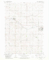
1980 Map of Odebolt West
USGS Topo · Published 1980About this map
Arthur and Odebolt anchor this agricultural landscape in Sac County, positioned along the industrial corridor of the Chicago and North Western railroad. The terrain is defined by a dense network of drainage, where Hoskins Creek and Odebolt Creek wind through the township divisions of Blaine, Richland, and Wheeler. The map reveals the infrastructure of small-town Iowa life in the late 20th century, from the Arthur Ch and Hayes Cem to the municipal Sewage Disposal Ponds and a hilltop Water Tank. To the south, the headwaters of the Soldier River and several creek branches like Otter Creek and Porter Creek illustrate the rolling topography that dictated the placement of rail lines and local roads.
Find a feature on this map
21 named features on this map. Tap any name to fly to it.
Don’t see what you’re looking for? This feature index may not catch every label — zoom into the map to look around manually.
Map Details
Editions of this 1980 Odebolt West Map
This is the sole edition of this map. No revisions or reprints were ever made.
Other maps of this area

1954 · Fort Dodge
USGS Topo · 1:250,000

1957 · Fort Dodge
USGS Topo · 1:250,000

1958 · Fort Dodge
USGS Topo · 1:250,000

1967 · Ida Grove
USGS Topo · 1:24,000

1967 · Ida Grove NW
USGS Topo · 1:24,000

1971 · Schleswig
USGS Topo · 1:24,000

1971 · Kiron
USGS Topo · 1:24,000

1980 · Odebolt East
USGS Topo · 1:24,000

1980 · Early
USGS Topo · 1:24,000

1980 · Boyer
USGS Topo · 1:24,000