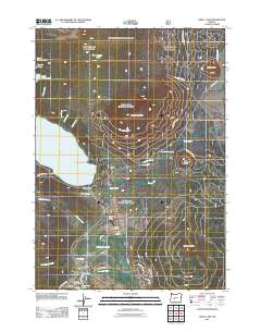
2011 Map of Odell Lake
USGS Topo · Published 2011About this map
Crescent Lake and Odell Lake dominate this alpine landscape of the Cascade Range, centered on a critical mountain corridor that serves recreation and transportation alike. The settlement of Crescent Lake is anchored by the Crescent Lake Post Office and Crescent Lake Resort, providing a hub for the various seasonal facilities scattered through the timbered terrain. This 2011 survey documents a dense network of forest service and local roads, including Lava Odell RD and Royce MT Way, which navigate the slopes of Maklaks Mountain and Royce Mountain. Significant infrastructure for winter and air travel is evident through the Junction Sno-Park and the Crescent Lake State Airport, situated near Crescent Lake Junction. The map also captures numerous smaller water bodies and points of interest, such as Maiden Lake, the Rosary Lakes chain, and the distinctive Chinquapin Point on the western shore of Odell Lake.
Find a feature on this map
40 named features on this map. Tap any name to fly to it.
Don’t see what you’re looking for? This feature index may not catch every label — zoom into the map to look around manually.
Map Details
Editions of this 2011 Odell Lake Map
This is the sole edition of this map. No revisions or reprints were ever made.
Other maps of this area

1917 · Diamond Lake
USGS Topo · 1:125,000

1925 · Waldo Lake
USGS Topo · 1:125,000

1930 · Maiden Peak
USGS Topo · 1:125,000

1934 · Maiden Peak
USGS Topo · 1:125,000

1935 · Chemult
USGS Topo · 1:96,000

1941 · Chemult
USGS Topo · 1:125,000

1955 · Crescent
USGS Topo · 1:250,000

1956 · Waldo Lake
USGS Topo · 1:62,500

1956 · Summit Lake
USGS Topo · 1:62,500

1957 · Crescent
USGS Topo · 1:250,000