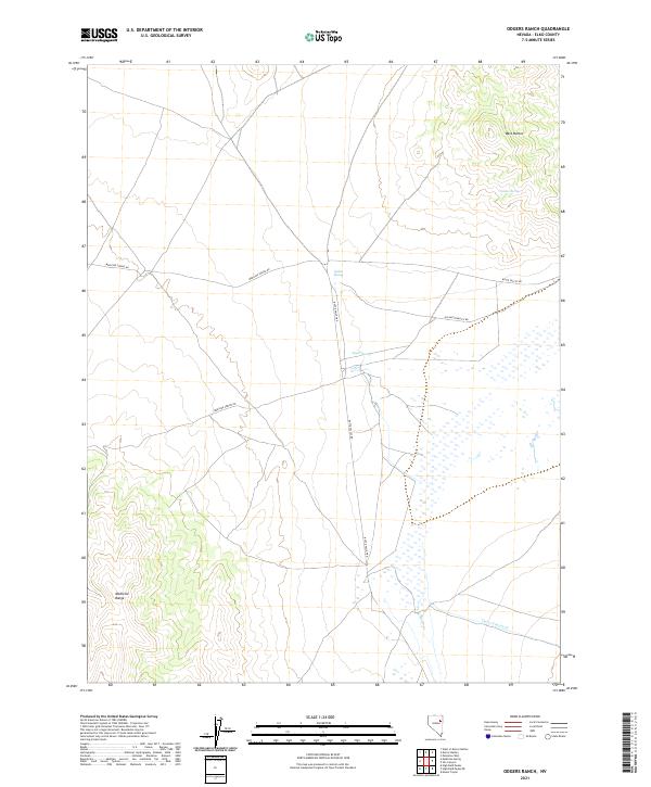
2021 Map of Odgers Ranch
USGS Topo · Published 2021About this map
The Medicine Range dominates the southwestern corner of this high-desert landscape in Elko County, providing a stark topographical contrast to the broad basin floor. Early transit and ranching routes define the human imprint on the land, most notably along Medicine Spring Rd and Butte Valley Rd. The presence of Old Buttevalley Rd suggests shifts in local travel patterns or ranching logistics over the decades. Water, the most critical resource in this arid environment, is pinpointed by a series of reliable sources including Quilici Spring, Fasano Spring, and Taylor Spring. These springs and the drainage of Taylor Canyon Cr would have been vital anchors for early homesteading and livestock management. To the northeast, the West Buttes rise as a secondary landmark, overlooking the seasonal flows of Butte Cr.
Find a feature on this map
16 named features on this map. Tap any name to fly to it.
Don’t see what you’re looking for? This feature index may not catch every label — zoom into the map to look around manually.
Map Details
Editions of this 2021 Odgers Ranch Map
This is the sole edition of this map. No revisions or reprints were ever made.
Other maps of this area

1955 · Elko
USGS Topo · 1:250,000

1958 · Elko
USGS Topo · 1:250,000

1962 · Elko
USGS Topo · 1:250,000

1965 · Elko
USGS Topo · 1:250,000
1984 · Mt. Taylor
USGS Topo · 1:24,000

1984 · Silo Canyon
USGS Topo · 1:24,000

1984 · West of Delcer Buttes
USGS Topo · 1:24,000
1984 · High Bald Peaks
USGS Topo · 1:24,000

1984 · Delcer Buttes
USGS Topo · 1:24,000
1984 · Palomino Well
USGS Topo · 1:24,000