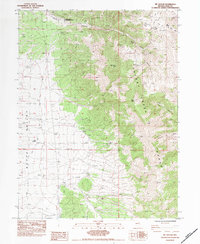
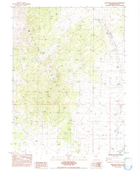
1984 Map of Mt. Taylor
USGS Topo · Published 1984About this map
The Odgers Ranch Indian Reservation sits at the northern edge of this high-desert landscape in Elko County, where the slopes of the Cherry Creek Range meet the flat expanse of Butte Valley. Recorded in the early 1980s, the terrain is defined by its water resources, featuring a series of named water sources like Main Camp Spring, Twin Springs, and Top Spring that were essential for the area's ranching and land use. Steep canyons including Taylor Canyon and Lion Canyon carve through the mountains, leading toward high points such as Mt Taylor and High Peak. A network of 4wd tracks provides the primary means of transit through this area, connecting isolated structures and a Corral used for managing livestock in the basin.
Find a feature on this map
18 named features on this map. Tap any name to fly to it.
Don’t see what you’re looking for? This feature index may not catch every label — zoom into the map to look around manually.
Map Details
Editions of this 1984 Mt. Taylor Map
This is the sole edition of this map. No revisions or reprints were ever made.
Other maps of this area

1955 · Elko
USGS Topo · 1:250,000

1958 · Elko
USGS Topo · 1:250,000

1962 · Elko
USGS Topo · 1:250,000

1965 · Elko
USGS Topo · 1:250,000

1984 · Currie Gardens
USGS Topo · 1:24,000
1984 · Paris Creek
USGS Topo · 1:24,000
1984 · High Bald Peaks SE
USGS Topo · 1:24,000

1984 · Silo Canyon
USGS Topo · 1:24,000
1984 · McDermid Ranch
USGS Topo · 1:24,000
1984 · High Bald Peaks NE
USGS Topo · 1:24,000