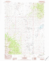
1984 Map of Odgers Ranch
USGS Topo · Published 1984About this map
The Medicine Range anchors the southwestern portion of this 1980s landscape, while the Delcer Buttes and West Butte dominate the northeastern horizon. This survey depicts a high-desert environment in Elko County defined by water management and ranching operations, centered on the Odgers Ranch and its network of irrigation ditches and intermittent ponds. The land use here is punctuated by specialized infrastructure for livestock and desert survival, including multiple water sources like Fasano Spring, Quillici Spring, and Taylor Spring. Evidence of early mineral exploration remains visible through scattered Prospects in the northern hills. The map also delineates a portion of an Indian Reservation, showing how administrative boundaries and traditional land use overlapped with private ranching interests in this corner of Nevada.
Find a feature on this map
15 named features on this map. Tap any name to fly to it.
Don’t see what you’re looking for? This feature index may not catch every label — zoom into the map to look around manually.
Map Details
Editions of this 1984 Odgers Ranch Map
This is the sole edition of this map. No revisions or reprints were ever made.
Other maps of this area

1955 · Elko
USGS Topo · 1:250,000

1958 · Elko
USGS Topo · 1:250,000

1962 · Elko
USGS Topo · 1:250,000

1965 · Elko
USGS Topo · 1:250,000
1984 · Mt. Taylor
USGS Topo · 1:24,000

1984 · Silo Canyon
USGS Topo · 1:24,000

1984 · West of Delcer Buttes
USGS Topo · 1:24,000
1984 · High Bald Peaks
USGS Topo · 1:24,000

1984 · Delcer Buttes
USGS Topo · 1:24,000
1984 · Palomino Well
USGS Topo · 1:24,000