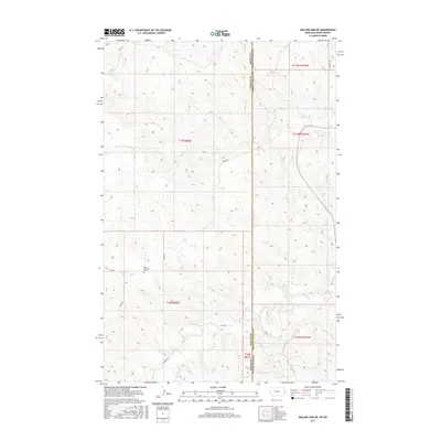
2017 Map of Odland Dam NE
USGS Topo · Published 2017About this map
Blue Mountain rises as a prominent landmark on the high plains of the Montana-North Dakota border, anchored by the Blue Mountain Cem situated along Bell Rd. The landscape is defined by the winding paths of the N Fork Cottonwood Cr in the northwest and Beaver Cr to the south, reflecting a topography shaped by seasonal drainage. This 2017 U.S. Geological Survey representation reveals a sparse ranching and agricultural network connected by named local routes like Divide Rd and W Bar Rd. The strict grid of the Public Land Survey System overlay highlights the intersection of Wibaux and Golden Valley counties, where the border line serves as a definitive divide across the high prairie. For those studying the borderlands, this map provides the exact placement of early landmarks and rural infrastructure relative to the state line.
Find a feature on this map
18 named features on this map. Tap any name to fly to it.
Don’t see what you’re looking for? This feature index may not catch every label — zoom into the map to look around manually.
Map Details
Editions of this 2017 Odland Dam NE Map
This is the sole edition of this map. No revisions or reprints were ever made.
Other maps of this area
1909 · Glendive
USGS Topo · 1:250,000

1953 · Watford City
USGS Topo · 1:250,000

1954 · Glendive
USGS Topo · 1:250,000

1957 · Glendive
USGS Topo · 1:250,000

1957 · Watford City
USGS Topo · 1:250,000
1958 · Glendive
USGS Topo · 1:250,000

1967 · Watford City
USGS Topo · 1:250,000
1974 · Hootowl Creek West
USGS Topo · 1:24,000
1974 · Trotters
USGS Topo · 1:24,000
1974 · Skaar
USGS Topo · 1:24,000