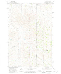
1974 Map of Skaar
USGS Topo · Published 1977About this map
Skaar occupies the northeastern corner of this 1970s landscape, positioned near the convergence of drainage systems along the Montana-North Dakota state line. The terrain is defined by an intricate network of watercourses, including the westward-flowing Smith Creek and the southern reaches of Henry Creek. This survey highlights the rural industrial activity of the period, particularly the presence of several Scoria Pits, which indicate the localized extraction of baked clay common to the region's geology. The area is divided by multiple political boundaries, where McKenzie and Golden Valley Counties meet, as well as the border with Wibaux County. These markers, along with the meandering paths of Deadman Creek and Poison Spring Creek, illustrate a sparse but functional ranching and extraction economy during the mid-1970s.
Find a feature on this map
10 named features on this map. Tap any name to fly to it.
Don’t see what you’re looking for? This feature index may not catch every label — zoom into the map to look around manually.
Map Details
Editions of this 1974 Skaar Map
This is the sole edition of this map. No revisions or reprints were ever made.
Other maps of this area

1909 · Glendive
USGS Topo · 1:250,000

1953 · Watford City
USGS Topo · 1:250,000

1954 · Glendive
USGS Topo · 1:250,000

1957 · Glendive
USGS Topo · 1:250,000

1957 · Watford City
USGS Topo · 1:250,000

1958 · Glendive
USGS Topo · 1:250,000

1966 · Skaar NW
USGS Topo · 1:24,000

1967 · Watford City
USGS Topo · 1:250,000

1974 · Hootowl Creek West
USGS Topo · 1:24,000

1974 · Trotters
USGS Topo · 1:24,000